“Almost unbelievable”: These were the words David Meller, leader of the minority Labour administration in Stockport, used to describe the results of a vote in December 2021. The vote was on something which the average person might struggle to find compelling: whether or not Stockport should join the Greater Manchester Spatial Framework (GMSF). This is an urban development framework in which the ten local authorities of Greater Manchester banded together to plan for homes and transport for the city region until 2039. The Liberal Democrat and Conservative councillors in Stockport voted for the town not to join the framework, citing fears that it would “concrete over the green belt”. As often happens when such emotions are deployed (and more on the green belt later), these councillors won the vote.
Like the Cassandra of urban planning, Meller estimated that, contrary to the other councillors’ reasoning, the decision to reject the GMSF would actually mean Stockport having to make space for more homes — 5,000 additional new houses, roughly. Fast forward to January this year, and like the unhappy prophetess, Meller’s words appear to be coming true — last week the Stockport planning committee’s decision to refuse an application to develop housing on Gatley Golf Course was rejected. This is their second attempt to refuse planning applications for large housing developments on green space that the council has lost in recent months.
After Stockport pulled out, the GMSF could no longer be called a Spatial Framework because, under the government's definition, a spatial framework was only such if all the councils in an area signed up. The plan that was agreed was a joint local plan and its name was changed to Places for Everyone to reflect this.
The recent developments are interesting, not because I am obsessed with the fate of golf courses in Stockport — but because it tells us a lot about the future of planning, not just in Manchester, but across the country. The local picture looks set to shape the national one. In December, housing and local government secretary Angela Rayner published an English devolution white paper in which she announced that all areas would have to develop a spatial development strategy — essentially like the one that Greater Manchester had been forced to abandon when Stockport withdrew (and which Places for Everyone is roughly similar to).
I was hopeful that this marked a return to a visionary era of planning. However, issues in Stockport and a recent vote in Oldham to attempt to pull out of Places for Everyone, make me doubt whether it is possible to plan in an era when people get so angry about things like building new homes. So this is my attempt to address the issue — to explain to you what on earth is happening with planning in Manchester. Then let’s have it out in the comments.
Let’s start at the beginning: what is a spatial framework, anyway? It’s a joint plan developed by local authorities to connect the dots. Instead of each council planning for their own strip of land, they band together to make a city-wide plan: to make sure you have enough homes, to put transport in place to connect neighbourhoods and to ensure there is enough space for the jobs you need.
Spatial frameworks are still something being thrashed out in England, part of an ever changing sequence of reforms. Urban planning in this country is still in its infancy, with its foundations dating back to 1947. Before that, you could do anything you wanted with land that you owned — build houses in the countryside, erect a castle in a car park, throw caution to the wind and set up an abattoir next to a school. This all changed with the 1947 Town and Country Planning Act that required landowners to secure planning permission for development (this also applied if you were just changing how you used an existing building).

Planning departments were set up in every council and they were tasked with drawing up plans to say what could happen on every bit of land. In the 1950s, legislation was passed on Green Belts. These had originally been called ‘Green Girdles’ (which probably wouldn’t have had the same appeal) and they were designated around all major cities to prevent them from sprawling into the countryside. Green belts are probably the most popular invention that town planners have ever come up with, both in terms of their comprehension (how many other planning policies have you heard of?) and their adoption — they now cover over 12% of England, whereas built-up areas cover just 10.5%.
When I started as a planner in the 1980s, Manchester had two tiers of planning: the Structure Plan, drawn up by the Greater Manchester County Council, which painted the big picture. The Structure Plan did things like determining the area that would make up the green belt; deciding where to put major pieces of infrastructure like motorways and perhaps most importantly, deciding how much housing each district should accommodate. Each of the ten councils then drew up local plans that decided where this new housing should go and zoned land for other uses: factories and shops, offices, where the town centres were, where the parks would be, and so on. After the Thatcher Government abolished the metropolitan counties, the Structure Plan disappeared and the job of deciding how many homes each council should accommodate was done as part of regional plans.
All this changed in 2010, when the coalition government was elected, along with its new secretary of state, Eric Pickles, a man who disliked all things regional. Cue: the Localism Act of 2011 which on the face of it sounded like a good thing – it devolved power down to the local authorities getting rid of those pesky regional planning authorities.
But left to their own devices, and faced with pressures from local people, most councils were not going to allocate enough housing to meet the country's needs. So in the name of localism, the government set housing targets for each individual council. It was accepted that some places didn’t have enough room to build the houses they needed, so the government introduced a duty for councils to cooperate with their neighbouring authorities. This meant, for example, that Oxford’s Labour Council had to somehow persuade its four surrounding Conservative Councils to help meet its housing need. It was hard enough to plan for housing within a single council. Adding a UN-style component where you had come to an agreement with other councils led by different parties didn’t go well.
Things were easier in Manchester because there was a long history of collaboration between councils. Because of this it was chosen to trial a new form of local government — to become a Combined Authority. Combined Authorities allowed councils to make decisions that would affect people across council boundaries – it allowed for big picture decision making at a regional level and in Manchester this included planning, hence the Spatial Framework.
I had some involvement advising on the second draft of the Spatial Framework and think on the whole it was a very good thing. One key advantage was how it allowed the whole conurbation of 2.8 million people to be planned together, in the way that great cities are planned in the rest of Europe. For example, the Mayor of Paris or Barcelona can decide where to invest in public transport, which areas should grow, where to focus new jobs, which open spaces should be protected. By contrast, after the abolition of the county councils urban planning in England was done as a mosaic of local plans which didn’t quite fit together. In Manchester there were ten local plans, but it was even worse in London where there were 33. A Greater London plan was reintroduced in 2004 and, when the Greater Manchester Combined Authority was set up ten years later, it was given planning powers similar to London.
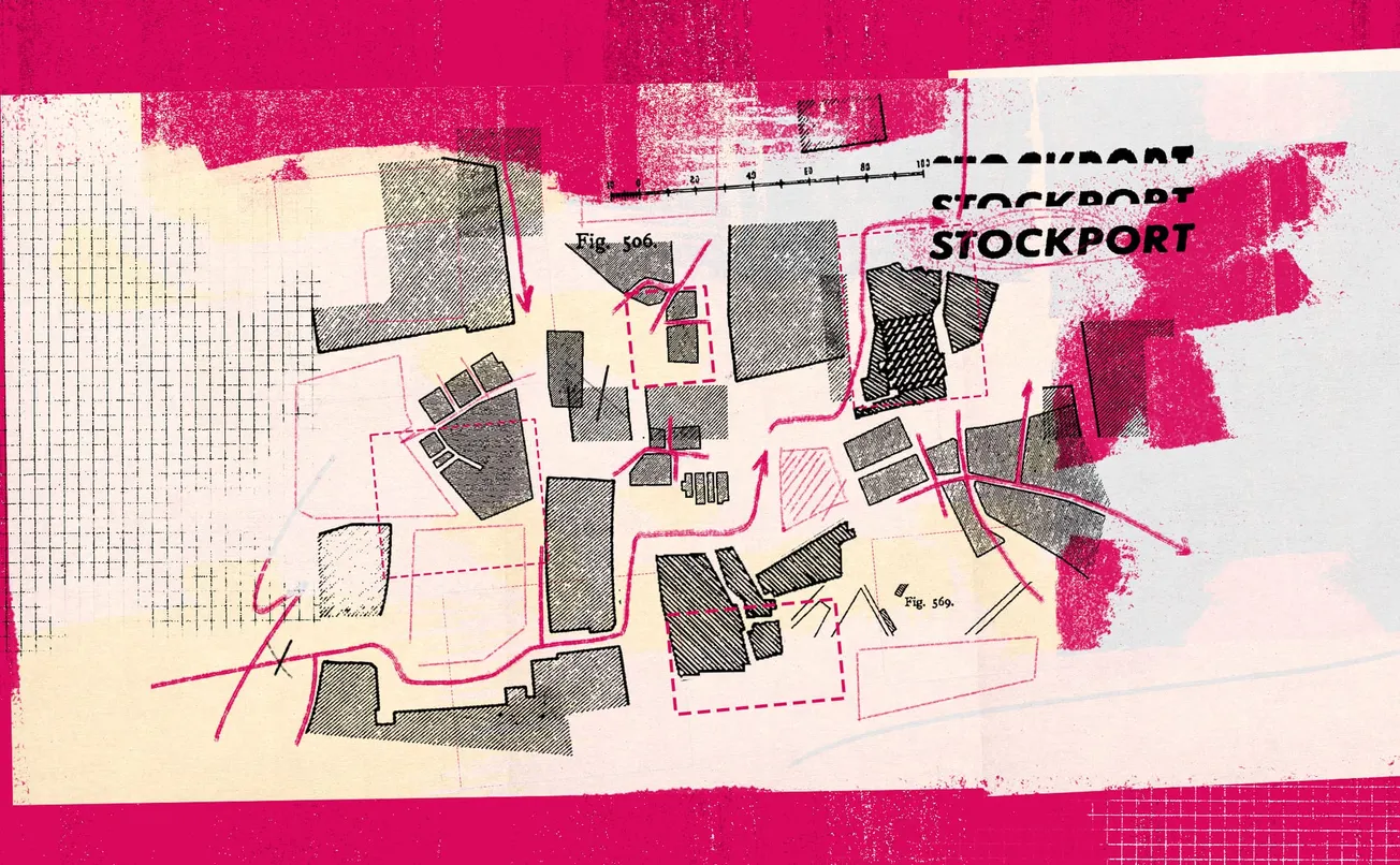
This big picture approach makes a lot of sense when you think about Greater Manchester. One idea we came up with when developing a narrative for the plan was how Greater Manchester is a ‘city of towns’ (a reference to the way London is often referred to as a ‘city of villages’). As such, it made sense for the joint plan to concentrate new housing in the eight transport corridors linking the centre to the major towns. The idea was that as many people as possible could live within 15 minutes of a tram stop, station or improved bus route. We came up with the idea of the 'octopus of accessibility' to describe this. While the term didn't quite catch on, the policy in Manchester was referenced by the Chancellor Rachel Reeves last week as a good example of a plan encouraging development around stations.
Besides the practical argument for a big, ambitious plan like Places for Everyone, there is also an emotional one to be made. We need to recapture the vision and excitement that accompanied planning back in the 40s. In October 1945 for example, Coventry City Council put on the ‘Coventry of the Future’ exhibition in a Drill Hall, which brought to life their plans for the city as an “efficient and beautiful setting…where proper emphasis is given to questions alike of traffic, housing, industry, recreation and amenities”. Thousands of people flocked to see it and every child in the city was taken to see the exhibition. It’s hard to imagine something like this attracting the same crowds today.
Previously, plans didn’t just engage architects, politicians and urban planners, but the average person. And when you compare the plans of post-war England to those of the present day, it’s easy to see why. Plans now are more jargon-heavy, boring, lacking in ambition and short term in their focus. The Combined Authority Planners wanted the Greater Manchester Spatial Framework to be different, to look beyond the dull detail, to tell a story about the future of the city, its places and its people.

But this message wasn’t coming across in the early drafts of the plan. Instead, people were only focused on one part of it. The GMSF was given powers to allocate land for housing and employment in the Green Belt. This has previously been something that only the local councils could do. And so of course the only detail of the GMSF people focused on were its proposals to build on a relatively small part of the Green Belt – and before long, it had attracted 24,000 objections. It was at this point that my team were brought in and we worked with the with the Combined Authority planners in 2017 and 2018 to develop a better narrative to try and communicate the plan. (I haven’t worked for them since so these are purely my personal opinions as a planner). Our job was to explain the big picture and bring out the vision behind the details.
But all the objectors saw was the new housing which they regarded as a bad thing and they wanted to know why building all these new homes was necessary. At the time the plan included over 200,000 homes to be built over 20 years (this dropped to 170,000 when Stockport pulled out). Our first argument — as I have explained in a previous article — was that Manchester should be much more bullish about growth if it was going to compete on a European stage. Greater Manchester (2.8 million) is still a relatively small city compared to say Barcelona (4.8 million) and growth needed to take place across the city not just in the city centre and central Salford.
To do this, looking at the green belt would be inevitable. The interactive green belt map of England shows that in London and Birmingham the green belt is just that — a band drawn around the city. In Manchester by contrast the green belt fills every gap and crevice between the built up areas. Drawn-up in the 1980s when the city was in steep decline, the idea had been to stop new suburbs being built and to focus what new housing there was in the city and towns. Now that Greater Manchester is growing rapidly, the logic just doesn’t hold anymore.
Obviously a green belt is enormously important, protecting the countryside as well as boundaries between towns and cities. But so sacred has the green belt around Manchester become that even the relatively modest nibbling around its edges of the green belt was politically almost impossible.
Which brings us back to Stockport. The politicians invoking the concreting over of the green belt in their opposition to signing up for the joint plan seemed to be ignoring the fact that this would mean they would be obliged to build more housing, not less. This joint plan had reduced Stockport’s numbers, redirecting growth pressures from the overheated southern districts of Stockport and Trafford to help regenerate the northern towns like Bury, Bolton and Rochdale by building more housing there. If Stockport didn’t form part of the framework, they would have to adhere to the higher targets imposed by the government.
We can see similar pushback with what’s happened in Oldham. Since August, councillors there have been discussing the possibility of withdrawing from the plan. On Wednesday, councillors will vote about whether or not to write to Secretary of State for housing, Angela Rayner, to ask for Oldham to be removed from Places for Everyone, with local Lib Dem leader Howard Sykes citing the green belt as one of his reasons. However Sean Fielding, who led Oldham Council during the development of the Greater Manchester Spatial Framework, up until 2021, recalls the borough getting a good deal in terms of what was offered by the plan. “Yes, there was construction proposed on Oldham’s green belt — but it was very minor, we’re talking about approximately 2.5% of the green belt there being used for new housing. Often people have a romanticised view of the Green Belt as some kind of picturesque biodiverse landscape, but it’s nothing to do with that, it’s a planning designation – one of Oldham Green Belt allocations including a former landfill.”
This idea of writing to Rayner feels like pure political theatre — since Oldham has already committed to Places for Everyone, they cannot simply withdraw. They would have to request the entire framework across all the other councils to be dissolved. It seems massively unlikely that Rayner would agree to do this. Once again, it feels like the green belt is being invoked to score political points. Like Stockport, if Oldham were to exit the plan they would end up having to build more houses than they’re obliged to currently — it would actually work against the green belt. According to Fielding, “Oldham’s housing target was 748 homes per year (680 plus a 10% buffer). Under Places for Everyone, the Council is only allocating enough land for the 680, with other parts of Greater Manchester picking up the buffer. Following the election, Oldham’s target is now 910 homes per year, so even more land would have to be taken out of the Green Belt for development without the ability to use the joint plan to shift some of that target out of Borough.”
Even if you set aside the fact that many of these politicians’ objections to Places for Everyone won’t actually help the countryside in their area, an inflexible attitude towards the green belt comes with disadvantages. As the Centre for Cities reports, the green belt can mean less houses being built, which pushes up prices for renters and buyers alike. As they write: “New houses in the UK are about 40 per cent more expensive per square metre than in the Netherlands, despite there being 20 per cent more people per square kilometre there than in England.”
It’s a sobering statistic. In my opinion, in some cases the green belt is strangling Manchester – pushing up our house prices and preventing it from growing as a city. So I thought it was a good thing when the Spatial Framework proposed that a series of sites across Greater Manchester should be taken out of the green belt and allocated for new housing. My concern is that the public does not always seem to understand this need for flexibility where the green belt is concerned – nor engage much with planning beyond their worries about the erosion of the green belt.
This lack of engagement is understandable! Urban planning is often granular and complicated. The problem is, this stuff really matters: it determines the delivery of housing that we all need (you may be perfectly happy with your flat, but are you happy with the rent you’re paying?). It shapes the construction of things like high speed railways and economic growth and the protection of the environment. Yet most planning documents are deadly boring, hung up on detail and lacking in vision and the planning system as a whole is a mess. It’s worth taking a moment to understand how we got here.